

Occupational Health and Safety
Engineering Solutions
Computer applications in Structures & Data Analytics
Enhance workplace safety with proven strategies
Apply risk management to your project planning
Safety Training
Risk Management


My other (newer) website: www. profkrishna.in will be updated with non-technical material
(Click HERE to reach it!)
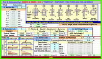
EXCEL Program for Basic Structural Analysis
CLICK THUMBNAIL BELOW


About ProfKrishna
Sharing sixty plus years of experience in civil engineering and safety management across India, USA, and Singapore.


Contact Us for Clarification or Further Guidance